TANZANIA
-
For detailed information about Tanzania, visit Tanzania
Website by Tanzania High Commission, London.
Geography
<click the image to see a bigger map>
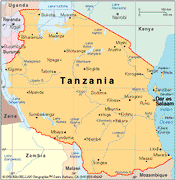 Tanzania
lies on the East African coast between 1 and 11 45' south, and 29 20' and
40 35' east. It covers an area of 945,166 square kilometers (about 42 times
the size of Britain), making it the largest country in Eastern Africa.
Just south of the equator, it borders Kenya and Uganda in
the north; New Congo, Rwanda, and Burundi in the west; and Zambia,
Malawi and Mozambique in the south, making it a splendid center from which
to explore eastern, central and southern Africa. Dar es Salaam is the capital,
although a new, central city, Dodoma, is projected to become capital by
the end of the century.
Tanzania
lies on the East African coast between 1 and 11 45' south, and 29 20' and
40 35' east. It covers an area of 945,166 square kilometers (about 42 times
the size of Britain), making it the largest country in Eastern Africa.
Just south of the equator, it borders Kenya and Uganda in
the north; New Congo, Rwanda, and Burundi in the west; and Zambia,
Malawi and Mozambique in the south, making it a splendid center from which
to explore eastern, central and southern Africa. Dar es Salaam is the capital,
although a new, central city, Dodoma, is projected to become capital by
the end of the century.
Tanzania's name signifies the union between Tanganyika and the two islands
of Unguja and Pemba, which with several other smaller islands constitute
Zanzibar.
Through the interior runs the Great Rift Valley, that vast fault-line
down the spine of Africa, that, in Tanzania, has created many fascinating
topographical features such as the Ngorongoro crater and Lake Tanganyika.
The Central Plateau (1,200 meters above sea level) is a huge expanse of
savanna and sparse woodland. To the north rises the 5,890-meter (19,340
feet) Mount Kilimanjaro, the highest mountain in Africa.
While the interior is largely arid, the 800-kilometer coastline is lush
and palm-fringed, as are the islands of Zanzibar, Pemba, and Mafia.
Tanzania is bordered by three great lakes: Lake Victoria in the north,
Lake Tanganyika to the west and Lake Nyasa to the south-west. Lake Victoria
is the source of the Nile.
History and Politics
Origins of humankind (according to secularist scholarship)
A 17.5 million year old skull found at Olduvai Gorge in Tanzania in 1957
indicated Africa as the probable site of human evolution. Homo erectus,
our immediate ancestor, first appeared about 1.5 million years ago and
is credited with the discovery of fire, the first use of stone tools and
recognisable speech.
Up to and including the 19th Century
Tanganyika (mainland part of Tanzania) is populated by many Bantu groups,
such as the Chagga, Hehe, Gogo, Yao, and Nyamwezi, and by the Masai and
other Nilotic peoples. It was defined by a series of treaties between European
states in the decade after 1886.
Arab influence
Trade between the East African coast and the Persian Gulf, of gold, ebony,
ivory and spices, go back millennia. The 13th - 15th centuries are called
the Shirazi Era after the sultans, who originated from the Shiraz region
of Persia (now Iran) and ruled more than 30 city states in East Africa.
The island of Kilwa, which had 10,000 inhabitants, its own mint and splendid
buildings, was the centre for the gold trade until the invasion of the
Portuguese in 1505. In 1698 the Portuguese centre in Mombasa (Kenya) was
overthrown by Arabs from Oman.
In 1827 the Sultan of Muscat, Seyyid Said, captured Mombasa and the
east coast region. He based himself in Zanzibar where he established clove
plantations. Cloves became the major export of Zanzibar.
European Influence
Up to 1850 Europeans knew little about the African interior. In 1855 German
missionary James Erhardt produced a map of Africa based on Arab accounts.
Explorers Richard Buxton, John Speke, David Livingstone and Henry Stanley
all played a part in mapping East and Central Africa and locating the source
of the Nile.
Between 1884 and 1918 Germany ruled much of the area they called Tanganyika.
Zanzibar became a British protectorate in 1890 and Tanganyika came under
British rule in 1918. Unlike Kenya, Tanganyika was never very heavily settled
by Europeans although 100,000 Tanganyikans fought for the Allies in World
War II.
Independence
Tanganyika attained full independence on 9th December, 1961 and Nyerere
became President. The United Republic of Tanzania was formed on 26the April,
1964 when Tanganyika united with Zanzibar. After Independence Tanzania
became staunchly socialist but since the mid-1980s there has been a swing
to a free market system. Nyerere retired in 1985 and was succeeded by Ali
Hassan Mwinyi. Mutli-party elections were held in October 1995 which put
Benjamin Mkapa as a president.
Economy
77% of the population live a subsistence lifestyle in the countryside.
Maize, millet (sorghum) and cassava are the staple crops, along with rice.
They are used to make a stiff dough called ugali (oo-gar-ly). Ugali or
rice, is eaten with green leaf vegetables, meat: beef, chicken or goat
or fish. Avocados, apples, bananas, mangoes, passion fruit, pears, pineapples,
onions, plantain, tomatoes, carrots, red beans, peanuts and sugar cane
are grown. Many farmers keep cattle, for milk and meat, and goats and chickens.
The country's major exports are coffee, cotton, cashew nuts, sisal,
tobacco, tea and diamonds. Zanzibar and Pemba export cloves and other spices.
Gold, tin and coal are also mined.
Culture and Languages
The country has a rich culture of music and dancing with many ceremonies.
Carving, pottery and weaving are traditional crafts still practised to
provide goods for everyday life, with many local variations in design.
The National langage of Tanzania is Kiswahili;
it is understood and spoken by almost everyone in Tanzania. Tribal langages
are also used. Tanzania has about 120 tribes each with its own tibal language.
Other Links
Tanzania
Page at U. Penn. African Studies
Kiswahili
Lessons
Tanzania Internet Project
Kamal Gordham's Zanzibar
Archives
UKWELI
NI HUU (KUUSUTA UONGO) A book about politics in Zanzibar before and
soon after 1964 Revolution (In Swahili)
News
The Express
Daily News
Gazeti la Rai
Majira
IPPMedia
AN-NUUR
 Contact us:webmaster@islamtanzania.org
 Tanzania
lies on the East African coast between 1 and 11 45' south, and 29 20' and
40 35' east. It covers an area of 945,166 square kilometers (about 42 times
the size of Britain), making it the largest country in Eastern Africa.
Just south of the equator, it borders Kenya and Uganda in
the north; New Congo, Rwanda, and Burundi in the west; and Zambia,
Malawi and Mozambique in the south, making it a splendid center from which
to explore eastern, central and southern Africa. Dar es Salaam is the capital,
although a new, central city, Dodoma, is projected to become capital by
the end of the century.
Tanzania
lies on the East African coast between 1 and 11 45' south, and 29 20' and
40 35' east. It covers an area of 945,166 square kilometers (about 42 times
the size of Britain), making it the largest country in Eastern Africa.
Just south of the equator, it borders Kenya and Uganda in
the north; New Congo, Rwanda, and Burundi in the west; and Zambia,
Malawi and Mozambique in the south, making it a splendid center from which
to explore eastern, central and southern Africa. Dar es Salaam is the capital,
although a new, central city, Dodoma, is projected to become capital by
the end of the century.